Paddle Florida®
Over 100 Florida Paddling Destinations
E-Z Maps... Photos... Reports...
You are here > Home >
North Florida >
Suwannee River - Overview
Updated: November 2019
Paddling on the Suwannee River
First Things To Know... plus 100's of River Photos (in-sequence)
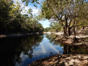
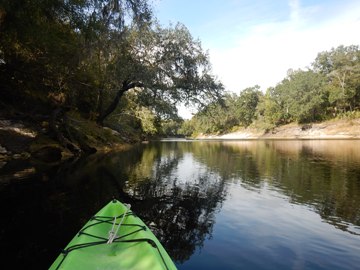
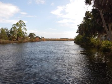
The iconic Suwannee River - made famous by the Stephen Foster song "Old Folks at Home," now Florida's State song - is a federally designated wild river flowing from the Okefenokee NWR in Georgia over 240 miles to the Gulf of Mexico. Most shoreline is now protected. Wildlife and fishing abound. The 171 mile Suwannee River Wilderness State Trail begins at White Springs, FL. For paddling purposes, we've divided the River into three Regions - Upper River, Middle River, and Lower River, each with its own paddling "flavor." All Regions contain in sequence photos from launches (over 30 shown) to give readers a good "feel" for the Suwannee as it changes on its way to the Gulf. (Map, sample photos below)
Distance: 242 "river miles" (see definition below). Designated Trail is 171 river miles.
Location: Hamilton, Suwannee, Gilchrist, Levy and
Dixie Counties (FL); Clinch County (GA)
Difficulty Easy to Difficult (water levels key in Upper and Middle, wind and tide in Lower)
Tidal: No in Upper and Middle Regions; Yes in Lower Region (nearing Gulf)
Launch points: Numerous, documented by Region (See
map)
Nearby points of interest: See individual Regions, links below
Rentals/Outfitters/Tours:
See by Regions served, links below
Support and Advocacy:
Page Summary:
- Paddling by Region
- Upper, Middle, Lower - First Things to Know
- Fast Facts
- More Information and Resources
See Overview page for all Suwannee River Regions.
Paddling by Region
The Suwannee River is often divided into 3 Regions based on "geology." For paddling purposes, here the River is divided into 3 Regions based on the flavor or characteristics of the paddling. (Regions are similar, but not the same.) See photos from over 30 launches.
Upper Region - Suwannee River
Okefenokee NWR (GA) to White Springs (FL)
Wild, remote, some nice out-and-back options. A few paddle straight through. Good for small kayaks, canoes, and solitude.
Middle Region - Suwannee River
White Springs to Branford
Most popular for paddling. Getting wider, fed by the Alapaha and Withlacoochee Rivers. Clear springs become a defining feature.
Lower Region - Suwannee River
Branford to Gulf of Mexico
Wider, deeper, motorboats. Some large springs, then more tidal towards the Gulf, best for experienced paddlers and sea kayaks.
First Things to Know
- "River mile" system. In the USA, a "river mile" is a measure of a river's distance from the mouth.
Mile numbers increase going up river.
Most river maps use this system. Most paddling is done down river. This system
may seem backward at first, but people quickly get used to it. For paddlers,
the "first launch" is at mile "242" in Georgia. The Wilderness Trail begins
at mile "171" in White Springs, FL and ends at mile "0" on the Gulf of Mexico.
The last landing is at mile "3.9."
- Water levels are key. Using the USGS gauge at White Springs as a guide (gauge #02315500 , near bottom of page, see "Gage height, feet"), paddlers can get a good estimate of water levels along both the Upper and Middle Regions. On the Lower Region, wind and tide become the key factors. At extreme high water, paddling is hazardous along the entire River.
River level below 50'
A few areas too low to paddle, some portaging. Slow current.
Between 51' and 58'
Best water levels for paddling. Current varies, slow to moderate.
Between 59' and 63'
Swift current, water at tree line in areas. Experienced paddlers only.
River level above 64'
Danger, very fast moving current. Paddling not recommended.
- Plan smart. This is a surprisingly remote area. Tiny towns, mobile service spotty at best, pop-up showers, shoals, leaping sturgeon, and more - be well prepared. Know the weather and bring dry bag, water shoes (jagged limestone eats flip-flops), hat, sun screen, plenty of calories, and about double the water you think you'll needed. (Please, no single-use plastic; not illegal but...) For many visitors, experienced local outfitters are the people who make it all happen. These are private businesses that provide canoe and kayak rentals and shuttle services (see Resources below).
Many public launches and private/public land partnerships make long distance paddling trips practical and more comfortable, especially for groups. Hubs are small towns that provide river access with full facilities. Camping and/or other accommodations are available at public and private parks along the River. The State maintains five River Camps in remote areas along the Trail (reservations required). These have screened shelters, picnic pavilions with grills, restrooms with showers, and tent camping.
Fast Facts
-- Much of the Suwannee River is the site of the prehistoric Suwanee Straits that separated peninsular Florida from the panhandle.
-- Below mile 177, a limestone terrace creates shoals, which at medium flow (59' - 61') become Florida's only Class III rapids (1/4 mile portage).
-- The Suwannee River is the only major waterway in the southeastern United States that is still unspoiled.
-- In the 1780s, the secluded bays and inlets of Suwannee Sound were rendezvous points for pirates.
-- After the Civil War, several steamboats operated on the Suwannee. The last ended service in 1923.
-- In 1884, Albert S. Gatschet - an ethnologist with the US Geological Survey - theorized that "Suwannee" was derived from the Creek Indian word sawani, meaning "echo." Today, we know this theory is probably not correct, but local officials realized it made for a good story, so it stuck.
-- Considered "healing waters," natural springs were Florida's first tourist attractions. The sulphur springs at White Springs, FL were especially popular, with 14 luxury hotels in operation in the late 19th century.
-- Stephen Foster was America’s first professional songwriter, penning the song "Old Folks at Home." In 1935, it became Florida's official State song. Foster never visited Florida and he never saw the Suwannee River.
More Information and Resources
Suwannee River Overview... Catalog of Resources
Water Levels are Key...
- USGS, White Springs - Gauge #02315500 - scroll down to "Gage height, feet. Most recent..." and compare reading to guidelines above
- MySuwanneerRver.org (SRWMD) - another resource for water levels, includes other North Florida rivers and lakes. Scroll down to Suwannee River > White Springs. Easy to read, but updates may differ from USGS above.
Florida State Parks Publications...
- Suwannee River Wilderness State Trail
- Suwannee River Outfitters
- Florida State Parks Reservations site
Suwannee River Paddling Guide...
- Guide by "Visit North Florida" (pdf, 72 pages!)
SRWMD Suwannee River Map...
- Detailed River Map (.pdf, 2 pages) - shows partnership lands and key features. Useful with Google map above.
Echo River YouTube Video...
- A History of the Suwannee - about 5 min, professionally done, tells of legends and the story behind "Echo River."
View great paddling by FL Region or Listed A - Z
PaddleFlorida.net... Find Florida's Best Recreational Paddling,
by Kayak, Canoe, and Paddleboard too.
Copyright © PaddleFlorida.net. All Rights Reserved. Paddle Florida®